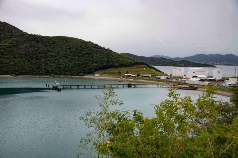
Exploring further at presqu’ile Ducos yesterday, a large peninsula just to the north of Noumea, which used to be completely given over to the penal colony (as far as I can gather). We visited initially guided by Emmannuelle of ATP (Association Temoignages du Passe), and saw the conserved prison block at l’anse Undu (‘anse’ means bay or cove), the cimetière des gardiens (prison guards) at Numbo, and viewed the former location of Louise Michel’s hut from a vantage point up on the road, looking down towards what is now known to Google maps as ‘Entrepôt Petrolier et Gaz Total’, a large industrial site spanning the width of the presqu’ile at this point, rendering Koumourou, the tip of the peninsula, inaccessible to the public.
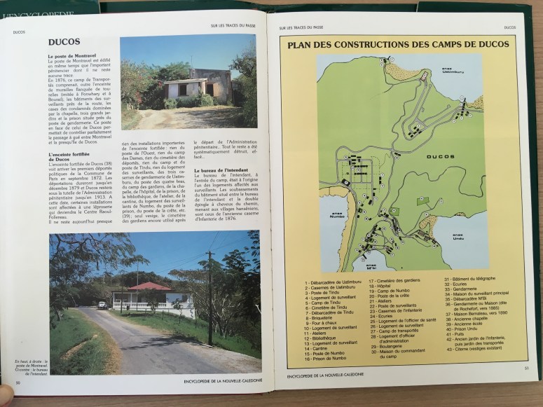
Returning to Ducos, I wanted to take a little more time and work out how the maps I’ve seen of the penal colony here ‘play out’ in the places as they are today. I used a map from the ‘Encyclopedie de la Nouvelle-Caledonie’, volume 9 ‘Sur les traces du passe’ by Marcel Petron and Philippe Godard:
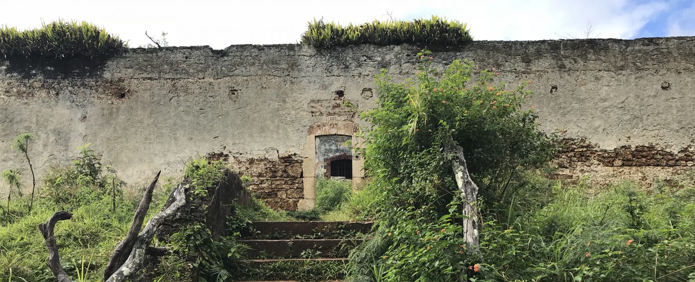
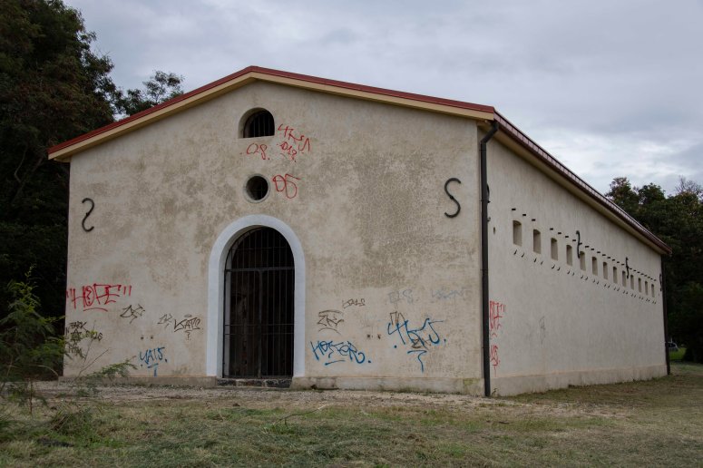
I began at anse l’undu, on the southern side of the peninsula, where we had been guided previously to see the prison building, which is still standing and has been restored with a new roof. It doesn’t have any contextual signage and I was glad to have been shown it first, as it’s within a small community area that has entrance gates (open) and I wouldn’t have read it as somewhere one was allowed to go into if I’d been exploring on my own.
This is what remains of no.40 on the encyclopedie map, clearly showing a much more extensive set of buildings as part of the penal colony.
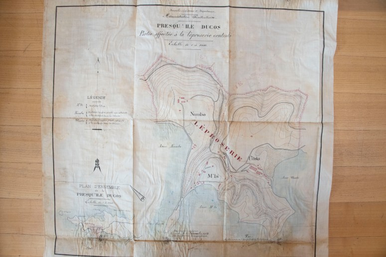
This is a map of Ducos made in 1885 by the Service Topographique:
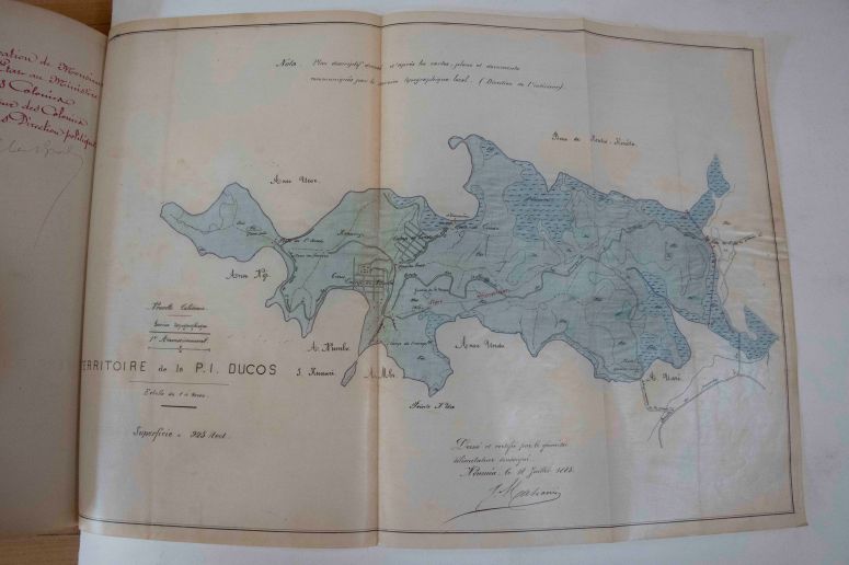
ANOM CR 123 H839 Proces-verbaux de delimitation et plans 1885/1890 Ducos 1885
Image courtesy of Archives National d’outre mer, Aix-en-Provence, France
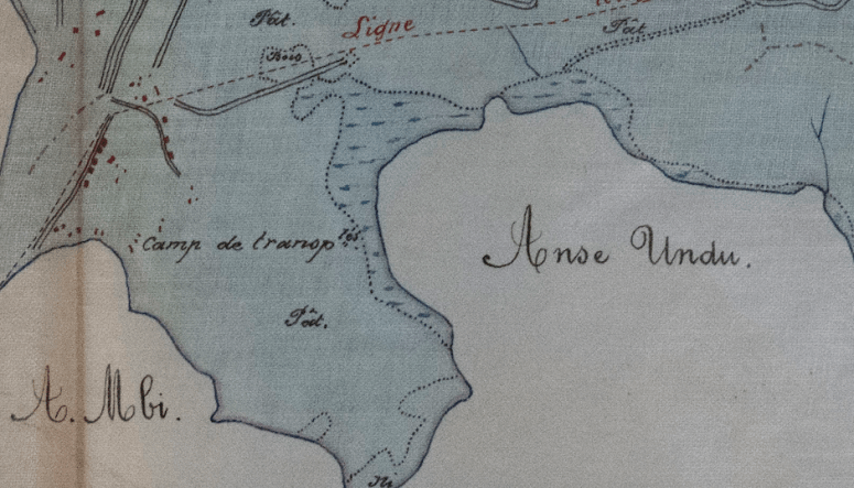
Here we see the penal colony presence marked with the label ‘Camp de transportation’ but without buildings being depicted yet:
I drove back up the steep hill to rejoin the main road in search of the cimetière des gardiens at Numbo, no.17 on the encyclopedie map:
This is all that remains of the penal colony at Numbo – driving down to the far end of the road took me to the entrance to another industrial area, so the tip of this promontory is inaccessible to the public. From looking at Google maps the way leading north east towards Undu appears to be open, but it’s not in practice. The rue des Frères Terrasson (running down the eastern side of Baie de Numbo) is lined with industrial establishments on its western side, and on its eastern side north of the steep rock wall. It leads north towards the cimetière des gardiens at Numbo.
The cimetière has been renamed in Google maps as cimetière de Numbo, neatly removing mention of the cemetery’s history as part of the penal colony:
In this detail of a 1913 map by the Service Topographique of the Administration Penitentiaire, I think the cemetery is indicated by the scribble-marks area beside the ‘L’ of ‘LEPROSERIE’ – it’s not labelled but corresponds with the present day location of the cemetery and suggests it was previously rather larger. Although this needs developing as reference to other maps makes me think this may indicate an area of mangroves.
ANOM CR 27 Box H2035 NC Ducos 1913
Image courtesy of Archives National d’outre mer, Aix-en-Provence, France
I continued towards the end of the presqu’ile, retracing my way towards Baie des Dames. With the group led by Emmannuelle, we looked down towards the site, marked by two palm trees. There are no visible indications that this used to be a part of the bagne, and there are no remnants at all to be seen.
I drove down to the gates of the entrepôt and turned the car around, not queried by anyone but it’s the sort of site where I tend to feel people might be wondering why you’re taking photos – this is well away from the tourist areas of Noumea and I would guess a few people must end up down there simply needing to turn around and head straight back again.
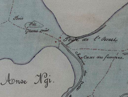
Here we see the isthmus in close-up from the 1885 map, showing ‘cases des femmes’ (or ‘women’s huts’) slightly east of the present-day palm trees:
And the contemporary view via Google maps of the same location, showing the entrepôt and the contemporary name for this bay, ‘Baie des Dames’, in place of the 1885 label of Anse Ngi:
Returning to the north east and heading back towards Noumea, I wanted to look for the débarcadéres (jetties) at Tindu in the north of the peninsula. I have become rather attached to the idea of the débarcadéres at a number of the penal colony sites, both here in New Caledonia and in French Guiana, as the places of arrival for the people beginning their experience of imprisonment at each particular place. They have left recognisable traces at a number of sites we’ve seen so I wanted to see if there was also anything remaining of two débarcadéres at Tindu:
Number one, Débarcadère de Uatimburu, has been preserved and re-fashioned but remains a visible structure in the cove:
And as depicted by Google maps satellite view:
Number 7, Débarcadère de Tindu:
These sites are certainly not presented for tourist consumption in any way, but I wanted to get a sense of the extent of the area involved in the penal colony at Ducos. From looking at the archive maps it had become one name to me, Ducos, but I think distinguishing its parts is worthwhile, especially as the peninsula is now a mix of heavy industry with areas of housing at Tindu.